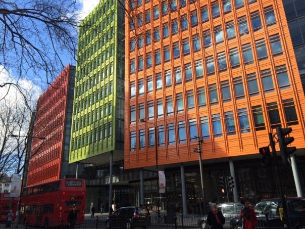
On a weekday lunchtime the brightly coloured Central Saint Giles, to the east of Oxford Street and Tottenham Court Road, is buzzing with activity. Workers pour out of their offices into the shops and restaurants set around a covered courtyard forming the heart of this £450 million development. On either side are two buildings towering 15 storeys into the sky, home to Google and other companies. Designed by Italian architect Renzo Piano and completed in 2010, Central Saint Giles has quickly become a West End landmark. Passers-by can hardly miss the place thanks to its distinctive facades, covered with more than 130,000 bright green, orange, lime and yellow glazed tiles.
With the Crossrail construction work taking place just around the corner, this area is going through an enormous amount of change. The new Tottenham Court Road station will open in time for the launch of the line that will bring fast travel across London from 2018. Even Centre Point, one of London’s first skyscrapers and completed in 1966, is getting a makeover – apartments will replace what has in the past been occupied by offices. Once development around Tottenham Court Road is complete property speculators who invested in real estate several years ago will make a tidy profit.
But as a result of all the change in the area, St Giles, which has a history stretching back more than a thousand years, has lost its identity. Indeed, St Giles High Street is a short stretch in central London with little more than a pub and a convenience store, set across from Central Saint Giles. Surrounded by modern developments and sandwiched between Covent Garden, Soho and Oxford Street, it’s one of the capital’s lost neighbourhoods.
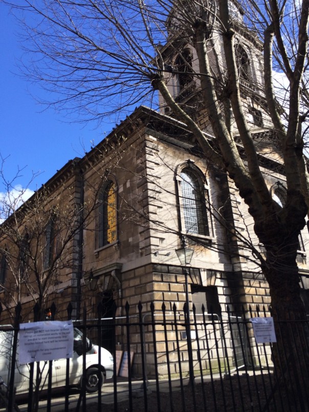
What’s probably oblivious to most that pass through this area on a daily basis is that it was once notorious for being one of London’s most unruly slums, where thieving and prostitution were rife. Given that streets have been built over and buildings demolished, traces of it have virtually disappeared. St Giles parish church (a religious institution since Saxon times), for example, is one of the few landmarks that would have been familiar to visitors to the area two hundred years ago.
When the clergyman Thomas Beames travelled here as part of research for his 1852 Rookeries of London book, he found thousands of destitute people living in “crumbling houses, flanked by courts and alleys…… in the very densest part of which the wretchedness of London takes shelter.” For him, it was like entering a different world:
“You have scarce gone a hundred yards when you are in The Rookery. The change is marvellous: squalid children, haggard men, with long uncombed hair, in rags, most of them smoking, many speaking Irish; women without shoes or stockings – a babe perhaps at the breast, with a single garment, confined to the waist by a bit of string; wolfish looking dogs; decayed vegetables strewing the pavement; low public houses; linen hanging across the street to dry; the population stagnant in the midst of activity; lounging about in remnants of shooting jackets, leaning on the window frames, blocking up the courts and alleys; with young boys gathered round them, looking exhausted as though they had not been to bed.”
Visiting the (now lost) George Street and Church Lane in St Giles, Beames found it hard to comprehend how up to 40 people could manage to sleep in a single room. Complete strangers slept next to each other, paying the landlord of the property a small amount for the privilege of a night’s stay. Inequality was rife in this district. Just a year before Beames published his book, statistics showed that there were 221.2 people per acre living in the district, compared to 16.2 and 5.3 per acre in Kensington and Hampstead respectively.

The residents suffered from “the want of water, with which these courts are very inadequately supplied, even where it is turned on; and this takes place, in many instances, only twice a-week, though the companies have a plentiful supply at command; and few investments have turned out so profitable as those made in the shares of these different societies.” Conditions were terrible given that “many of the houses are so far below the level of the street, that, in wet weather, they are flooded; perhaps this is the only washing the wretched floorings get; the boards seem matted together by filth.” Beames described one shocking scene:
“In a back alley, opening into Church street, was a den which looked more like a cow-house than a room for human beings – little, if any light, through the small diamond panes of the windows; and that, obstructed by the rags which replaced the broken glass-a door whose hinges were rotting, in which time had made many crevices, and yet seventeen human beings eat, drank, and slept there; the floor was damp and below the level of the court; the gutters overflowed; when it rained, the rain gushed in at the apertures.”
Those living in the Rookery lived a precarious life, getting by on petty theft, begging and from selling goods on the streets. Beames said that “oranges, herrings, water-cresses, onions, seemed to be the most marketable articles.” Others worked as sweepers or stray luggage porters. Some inhabitants spent a month in a property, others a week and others still were “trampers”, moving on after a single night, carrying all their life’s possessions with them.
Beames looked to history to understand how the Rookery in St Giles had grown to be as miserable as it was in his day, tracing it’s development from being a medieval leper hospital founded by Queen Matilda, wife of Henry II, in the 12th century. The marshes and open fields in which it was built provided a physical barrier separating it from London. While the hospital only survived until the mid 16th century, its presence in St Giles firmly establish the parish as a place for outcasts – a label that the district is only really now shaking off. As early as the mid 17th century, church wardens reported “a great influx of poor people” as vagrants expelled from the city settled in the St Giles and sought its generous charitable relief.
Although from early on there was a lot of poverty in the parish, it also attracted some wealthy residents from the late 16th century. But from Georgian affluence in 18th century, those that could afford it moved westwards to newly built squares and the area declined rapidly to the state that Beames described in his book. As I’ve written before, William Hogarth captured St Giles in a 1751 print called ‘Gin Lane’. In a busy scene set in front of the parish church, Hogarth pictured the poverty and despair of a community dependent on gin. The only businesses that thrived were those linked to the sale of the spirit.
By the 19th century many campaigners were highlighting the plight of the inhabitants of St Giles. Residents themselves wrote to the Times in 1849 to express their protest: “We live in muck and filth. We aint got no priviz no dust bins, no drains, no water-splies, and no drain or suer in the hole place.” But authorities’ were doing little – their solution was to simply bulldoze slums and replace with new roads, as was the case with New Oxford Street (completed in 1847). While the venture may have been a commercial success, no thought was given to where the 5,000 made homeless by the construction project would be housed. Beames was scathing:
“If Rookeries are pulled down, you must build habitable dwellings for the population you have displaced, otherwise, you will not merely have typhus, but plague; some fearful pestilence worse than cholera or Irish fever, which will rage, as the periodical miasmata of other times were wont to do, numbering its victims by tens of thousands!”
As slums were torn down over the course of the 19th century inhabitants were simply moved on to some of the other Rookeries in London. Following in the footsteps of Thomas Beames and his 1852, I’ll be visiting five more of these districts in the coming weeks and will see that St Giles is by now means an isolated case.

Reference
- Lost St Giles and its poverty past, Past in the Present, 9 March 2014, by MARKGEE98 https://pastinthepresent.net/2014/03/09/lost-neighbourhood-of-st-giles-hides-its-poverty-past/
