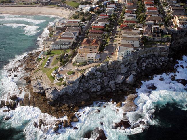
To many tourists, Bondi, in Sydney’s Eastern Suburbs, is just a beach, a long expanse of sand and surf. However, Bondi beach itself is divided between the suburbs of Bondi and North Bondi – and don’t try to tell any local they are all the same area! North Bondi us partly situated on a long point of land creating the northern head of Bondi Bay. Wrapped around the point are steep cliffs, and rugged rocks that are lashed by the full fury of the surf. This barren area is known as Ben Buckler.

• It was named for a convict Benjamin Buckler or Ben Buckley, who lived locally with the Aboriginal people from 1810. His friend and fellow convict James Ives claimed he was killed near the point now bearing his name when the rock shelf on which he was standing collapsed. He also claims that the headland was formerly known as ‘Ben Buckler’s leap’.
• A variation on the story has a bushranger called Ben Buckley who, after taking part in many adventures and after obtaining his liberty, lived in a cave in the rocks at the northern end of Bondi Beach and was a known local character.
But is there a Governor Lachlan Macquarie connection? This was first raised in an anonymous letter to the Sydney magazine the Australian Town and Country Journal on 25 May 1878. The writer, using the nome de plume, ‘Old Colonist’ claimed that the name Ben Buckler was a corruption of a name bestowed upon the headland by Macquarie. He went on to argue that Macquarie named it ‘Benbecula’ in honour of the island of the same name located in the remote Outer Hebrides off the west coast of Scotland.
Macquarie was born on one of the Hebridian Islands, Ulva, and would have been familiar with other islands in this group. The west coast of Benbecula has golden sand beaches, including one long sweep of beach Poll na Crann, with sand dunes behind them, the same coastal environment as Bondi Beach had before its development. Macquarie was born on island of Ulva in the Inner Hebrides, Scotland in 1762 and may have visited Benbecula, although this cannot be confirmed.
Macquarie would have travelled along the South Head Road, (now Old South Head Road) which had been constructed in 1811 and along parts of this Bondi Beach and its northern headland would have been visible. Did it look like Benbecula from a distance?
In 1906 the discussion began again in a local paper The Bondi Weekly when a land subdivision on the headland, known as the Queenscliffe Estate, began rumours that Ben Buckler’s name was to be changed to Queenscliffe.
On 29 June 1915 Captain J. W. Watson of the Australian Historical Society decreed that ‘the name of Ben Buckler is a corruption of Ben-becula, the name given by Macquarie.’ There is no primary evidence for any of the claims for the name Ben Buckler, making the debate about it all the more fascinating.
Published by Waverley Library from Local History source material, 2012.
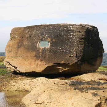
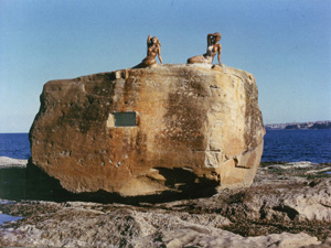
The Big Rock
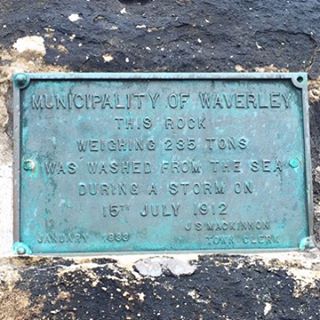
“Municipality of Waverley. This rock weighing 235 tons was washed from the sea during a storm on 15 July 1912. January 1933. J. S. MacKinnon. Town Clerk.”
It was fixed to the rock on 16 March, 1933. On Saturday 13 July, 1912 Sydney was under the influence of monsoonal activity resulting in a steady downpour of rain. Conditions deteriorated the following day and the weather was described by The Daily Telegraph as ‘a cyclonic storm – a bleak southerly gale raging, with fierce rain squalls. During the afternoon the rough weather on the coast continued with, if anything, greater fury.’
The Sydney Morning Herald described the weather as coming ‘from a cyclonic disturbance between Lord Howe Island and the central coast of NSW’ reporting that the wind was up to 113 k.p.h. along the coast, from Manly to Long Bay, beaches sustained serious damage. The wild weather continued over the weekend with newspaper reports describing waves at Tamarama as ‘rolling in like mountains’ and sea spray breaking at points ‘which had previously been unvisited by the waters of the Pacific’. Bronte Baths were damaged by this storm and the force of the sea threw huge boulders into the Bogey Hole.
The Watts family who lived in the old ‘Castle’ Pavilion, the forerunner to the current Bondi Pavilion, right on Bondi Beach reported being terrified by the storm as the south-facing beach bore the full front of the weather. It was after this wild weather subsided that a giant boulder on the North Bondi rock platform was first noticed. It was reported that the force of the mountainous seas which swept along the beaches during these storms had thrown up this enormous submerged sandstone rock from the ocean onto the rock platform. In November, 1932 it was grandly titled ‘Bondi’s Gibraltar’ by the Sydney Morning Herald which reported on Waverley Council’s decision to put a ‘tablet’ on the rock twenty years after its presence was first recorded, in order to record its history.
Cover of the Bondi View, June/July 2002.
Did it fall down – or was it thrown up? The long-accepted position on how The Big Rock came to be sitting on the North Bondi rock platform was that the boulder had been thrown up during the wild storms of July 1912, something that those who witnessed it had no trouble in believing. Soon after the storms a scientist, Carl A. Sussmilch, took measurements of the rock, talked to locals and calculated its weight at 232 tons. He noted deep eroded grooves near it which ran along the rock platform toward the sea and deduced that the force of the storm lifted the rock up from under the sea, flipped it over and with the aid of the strong wind skimmed it along the surface of the platform.

Regardless of some views to the contrary, the position that The Big Rock was washed up in the July 1912 became the accepted one and this position is repeated in most histories of Bondi Beach. In mid-2002 Bondi resident Lee Cass, then editor of local paper The Bondi View disputed the long accepted theory that The Big Rock was thrown up by the sea. His detailed rebuttal analyses the accepted wisdom about The Big Rock and finds it all wanting. He proposed an alternative view, that The Big Rock fell from the headland at Ben Buckler and furthermore that it was in place as long ago as 1888. His article ‘The Big Rock: exploding the myth’ appears in The Bondi View June-July 2002 edition a copy of which is available in Waverley Library in the Reference, i.e. non-lending, serial collection.
The Big Rock becomes Mermaid Rock in April 1960. For decades afterwards, despite having no mermaids, the rock continued to be referred to as Mermaid Rock. However that name, along with the memory of the mermaids who made it their rocky throne, has now almost disappeared and the boulder has gone back to its first, and basically self-descriptive title The Big Rock.
In June 2012, almost 100 years since the ferocious storm which is generally believed to have thrown up The Big Rock from its former watery home, extraordinarily powerful weather hit the east coast of Australia. This battered our beaches and the accompanying wild winds caused extensive damage. At Bondi huge seas rolled in, covering the sand and sending enormous waves crashing against the breakwater at the northern end of the beach and overrunning the promenade. Emergency service workers described it as possibly a ‘one-in-100-year storm’ it seems well-timed indeed.
Published by Waverley Library from Local History source material, 2012. Reference: ‘The Big Rock: exploding the myth’ from the Bondi View June-July 2012 ed,
The Mermaids

• Jan Carmody, who was Miss Australia Surf, 1959
• Lynette Whillier, champion swimmer and runner-up in the Miss Australia Surf, 1959
So Lyall erected them on the Big Rock at his own expense. He claimed that because they were placed a certain distance offshore the space they occupied was not under the jurisdiction of Waverley Council, but the Department of Lands. He claimed that the Department had approved his statues. The mermaids were installed on 3 April 1960.
One month after they appeared university students chiselled mermaid Jan from the Big Rock and removed her as part of a Commemoration Day prank! She was later recovered under mysterious circumstances at the Engineering School, Sydney University. Repaired, she was restored to the Big Rock to rejoin her fellow mermaid Lynette. The cost of repair met by public subscription – the public loved the mermaids so much that they paid for Jan to be put back together again.


Aboriginal Rock Carvings
Contemporary Bondi Beach is popular with surfers and sun-lovers. In earlier years, Aboriginal people also found it an attractive place, with its abundant nearby fresh water, fish and rocky shores full of shellfish. The name Bondi, also spelt Bundi, Bundye and Boondye, comes from the Aboriginal ‘Boondi’. According to some authorities, this means ‘water tumbling over rocks’, while the Australian Museum records its meaning as ‘a place where a fight with nullas took place’.
Early British arrivals identified Aboriginal pathways running from Port Jackson to the coast. In 1882, Obed West described Aboriginal men walking from Sydney harbour to Coogee or Bondi with bark canoes on their heads, looking for the best fishing spots. A midden of shellfish debris and artefacts at the edge of the dunes has now disappeared under modern development.
In 1899, a large cache of stone artefacts that came to be known as Bondi points were found at the northern end of the beach. These long thin blades were shaped to use as spear points and barbs and were first called ‘chipped-back surgical knives’ because they are shaped like scalpels.
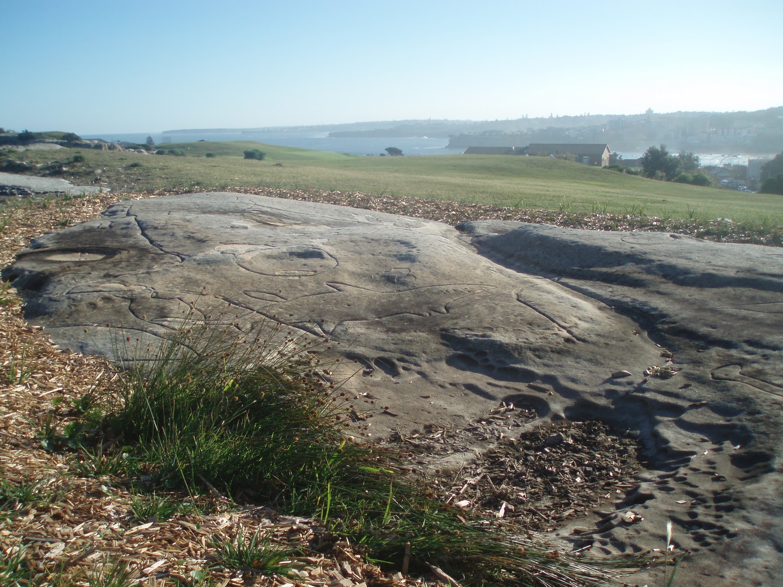
Situated on the southern or sea side of Bondi Golf Course, adjacent to a sewerage treatment plant, there stands a substantial panel of Aboriginal rock carvings depicting various fish species. They are carved into the flat sea-cliff at a fishing rock known to the Indigenous people as Murriverie or Marevera. They were formed by pecking at the rock surface with pointed stones or shells, and extended over 60 metres southwards.
The largest group shows an eight-metre figure of a shark that appears to be attacking a male figure that could be an iguana or lizard. This could be the first record of a shark attack at Bondi. It was earlier thought to be a whale, as there are two other rock engravings of whales at Bondi, but the dorsal and pectoral fins identify it as a shark.
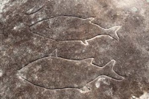
A separate panel shows two fish and a boomerang. The southernmost portion of the group has been cut deeper and is probably of an older date, possibly up to 2,000 years old. Ancestral footprints (mundoes) that once led to the site have now faded. It is assumed that the carvings were linked to a ceremonial ground overlooking the ocean.
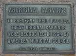
A low chain fence now encloses the site. The carvings were retouched and fenced in 1951. A plaque commemorates a misguided attempt in 1964 by Waverley Council to preserve the engravings by re-grooving them. They are listed on the State Heritage Inventory but are poorly drained, blistering, and in danger of being damaged. They deserve serious attention as evidence of the Aboriginal occupation of Bondi long before the blonde-haired surfers arrived.
The Ben Buckler Gun Battery
The Ben Buckler Gun Battery was constructed in 1892 as one of a set of three coastal defence fortifications for Sydney Harbour, the other two being Signal Hill Battery at Watsons Bay and the Shark Point Battery in Clovelly. These fortifications were the last link in Sydney’s outer defence perimeter, which was intended to defend Sydney from bombardment by an enemy vessel standing off the coast. The fortifications built in the 1890s around Sydney’s eastern suburbs were the culmination of some twenty years of construction of harbour defense installations that reflected the changing policy of the time to meet new technologies, threats and styles of warfare.
Gun emplacemen
The Ben Buckler Battery is a rare, intact concrete 1890s gun emplacement, which was designed and developed for the new BL 9.2 inch (234 mm) Mk VI breech-loading ‘counter bombardment’ British Armstrong ‘disappearing’ gun. The Australian colonies bought 10 of these, three for Sydney, plus an extra barrel, four for Victoria at Fort Nepean and Fort Queenscliff, and two for Adelaide, South Australia, purchased in 1888. The Adelaide guns were never installed at Fort Glenelg and the British government bought them back in 1915. The barrel of the gun that had been installed at Signal Hill Battery survives on public display at the Royal Australian Artillery Museum at North Fort, North Head.[citation needed]
The Ben Buckler gun, Serial Number 7319, is the only complete 9.2-inch in Australia and was the largest gun in New South Wales. The gun barrel weighed 22 tons and it took a total of thirty-six horses to transport the barrel from Victoria Barracks in Darlinghurst to the battery in North Bondi; the transit took over three weeks.
Soon after its arrival, the gun was installed on a hydraulically operated disappearing mount. The gun was located below ground level and beneath a domed iron shield set into a wall of reinforced concrete that was ten meters in diameter. The domed metal shield that covered the pit was intended to protect the gun from incoming shells.
Once the gun was loaded, the hydropneumatic action shunted it forward and up through a slot in the shield. After discharging, the recoil mechanism forced the gun back into its pit. This protected the gun crew while loading and made the gun a very difficult target for an enemy ship to hit.
Sometime in the 1950s the army vacated the site. The government was unsuccessful in finding a scrap metal buyer to remove the gun, so it buried the gun and gave the site over to parkland. The gun’s existence was forgotten until it was rediscovered in the mid-1990s by Water Board engineers planning a new pipeline. It is now classed as an architectural relic and is under the protection of the Heritage Council.

The “Spanish Proclamation”
From The Secret Visitors Project
High above Bondi Beach with spectacular views out to sea you will find a small rock engraving which became one of the proofs used by aviation pioneer Lawrence Hargrave in support of his theory that the Spanish had landed in eastern Australia in 1595. He thought that the Spanish had made this carving as their official record of their presence and possession of the land, and termed it the Spanish Proclamation. Hargrave’s argument convinced very few people and the story associated with the engraving remains largely forgotten.
Hargrave is best known for his aeronautical experimentation, for which he is rightly recognised as a pioneer. Much of this took place in the late 19th century; once the Wright brothers flew successfully his work was superseded by others. Perhaps in part driven by relevance deprivation, during mid 1906 Hargrave was inspired by the discovery of a cannon in Torres Strait and his own memories of work in the same area in the 1870s to develop a theory that the Spanish mariner Lope de Vega in the ship Santa Isabel [or Ysabel] had been separated from Alvaro de Mendana de Neira’s expedition to settle the Solomon Islands and had instead travelled as far south as Sydney Harbour, where they stayed for perhaps 3 years before being rescued.

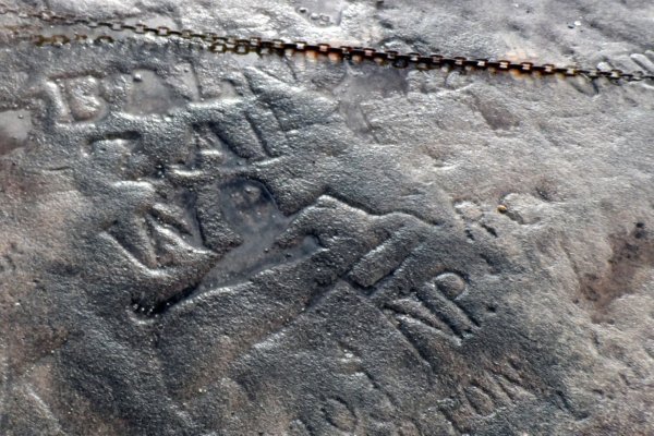
Figure 1. Hargrave’s recording of the ‘Spanish Proclamation’.
Hargrave presented his theory to newspapers and in a lecture to the Royal Society of NSW in June 1909. The second part of his talk was presented in December 1909 to strong negative reaction. The published Royal Society papers, and later self-published documents and newspaper letters introduced a range of evidence to support his theory. One of his key proofs was the engraving at Bondi.
The engraving
Description
The engraving [Figure 1] is located on the headland to the north of Bondi Beach, known since at least the 1830s as Ben Buckler. Later it was also called Meriverie [various spellings, earliest being Meriberri], which was also the name of the quarry that mined a basaltic dyke on the headland. The engraving is on exposed rock near the edge of the cliff, partly within a shallow natural depression that holds a few centimetres of rainwater. About 50 metres to the south is a large rock exposure that contains a number of Aboriginal rock engravings, later re-cut by Waverley Council. Immediately to the northwest is the tall chimney of the Bondi Ocean Outfall Sewer. The engraving is currently surrounded by a small chain fence.
The engraving shows two sailing ships in profile. Around and over them are a series of letters – BALN ZAIH – and other engravings such as a cross within a circle. They are engraved into the surface of the sandstone. They are oriented to be read from the west.
The full set of motifs are:
Ship 1 – port side view, curved hull, suggestion of rudder, sterncastle and two part forecastle, bowsprit. Measures 660 mm long by 220 mm high.
Ship 2 – starboard side view, curved hull, delineated keel, sterncastle, bowsprit, about 12 portholes marked by dots. Has deteriorated too much to allow measurement, but scaled from existing drawings is about 1000 mm long by 250 mm high.
Lettering – first line B A L N, second line Z A I H, third line W O. The O is divided into quarters with a vertical cross. Lettering height ranges from 135 mm for the Z to 150 for the B. The first two lines are about 500 mm long.
Line – a line 400 mm long with a small triangle at either tip.
The engravings were first noted by Campbell in his 1899 recording of the nearby Aboriginal engravings. He mentioned that these engravings looked much less weathered than the Aboriginal motifs [Campbell 1899: 11]. Watson and Vogan [Watson 1911] detected two different hands at work, while Hargrave conceded that the N, I and H were scratched rather than chiselled in [Hargrave 1914: 34]
When inspected in March 2010 the engraving was found to be in poor condition. Recent wet weather had resulted in part of the engraving being covered with standing water. The lettering is clear, as is Ship 1 at the bottom of the panel. The outline of Ship 2 to the right had all but disappeared, and could only be faintly detected.
Parts of the rock platform surface are exfoliating, where the hardened surface rind of stone had detached from the bedrock and popped off completely, exposing softer stone. The chains that had been erected around the panel are also dragging on the rock and abrading the stone.
Interpretation
Hargrave read the motifs as being a single coherent and purposeful message, cut into the shallow depression in one episode. In his scheme it was the semi-official proclamation of the survivors of Lope de Vega’s expedition, made after their rescue by the Santa Barbara in c.1600. In his reading the two ships are the Santa Isabel [or Ysabel] and the Santa Barbara. The lettering Hargrave interprets as Santa BArbara, Santa YZAbel for the ships and ‘L‘, ‘N‘, ‘H‘ being initials of the senior men present. ‘W‘ was the name they gave to this country. The cross in the circle was Spain’s symbol for conquest in the name of God.
Read together the symbols and letters meant, ‘We in the Santa Barbara and the Santa Ysabel conquered W… from point to point. By the sign of the Cross.’ The initials represent Lope de Vega and his three witnesses, N, I and H. This version appeared in his 1911 booklet and he maintained it essentially as is until his death. One variation that appeared in his later thoughts is that he thought W… referred not more generally to the eastern Australian coast but to an island formed from the higher land between Randwick to South Head, believing that this was separated by swamp or open water from the rest of Sydney in 1595.
Hargrave also believed that the name Meriverie itself was Spanish in origin, being Mare-y-ver-e = ‘Sea view’ [Hargrave 1914: 34].
History of the engraving
Hargrave’s interest
The headland at Ben Buckler had already been the scene of significant European activities before Hargrave’s attention was drawn to it. Quarrying the ‘white metal’ basaltic dyke at O’Brien’s Bondi Quarry began in 1860-61 and continued for decades. In 1888 a sewer vent was installed near the engravings as part of the Bondi Sewer. In 1910 it was replaced with the current sewer tower.
The engraving first came to notice when Aboriginal carvings were being recorded by WD Campbell, who produced a detailed corpus of engravings in the Sydney district for the Geological Survey of NSW. After describing the Aboriginal engravings immediately to the south he noted:
[s]ome clue as to the slow rate of decomposition of the rock surface is afforded by a small carving which has been done with a chisel, by a white man evidently. It is one chain north-easterly from the north end of this group; it represents the hulls of two small vessels with the old-fashioned high poop and forecastle in vogue at the time of the founding of the Colony. Although this is considerably weathered, it is not anything like so much as that which the group above has undergone [Campbell 1899: 11].
The earliest mention of the Spanish Proclamation by Hargrave is a 1:1 tracing that he made of the engravings onto linen sheet. The annotation that the engravings sat in a shallow depression that may have prevented ‘wanton vandalism’ is dated 12.3.1910 [Hargrave 1914: unnumbered]. Apart from this there is a note in his personal papers held in the Powerhouse Museum Archives dated to 18.4.1910, which follows the form Hargrave used when he had a bright idea and wanted to document it properly within his files. The note identifies the lettering and their equivalents which he would later propose as the translation. Other undated material in his papers includes comparative hull profiles of the Santa Barbara, Santa Isabel and Columbus’s Santa Maria.
The President of the Royal Australian Historical Society James H. Watson had already disagreed with Hargrave publicly over the origin of engravings of human and animal figures at Woollahra Point, suggesting that rather than being of Spanish origin they were done by convicts early in the colonial period. In Watson’s view the outstretched arms were meant to show a convict tied to a whipping frame [Watson 1909]. When Hargrave ventured more public comments in 1911 Watson issued a strong critique in a newspaper letter.
Regarding the Ben Buckler engravings the carvings on the Bondi cliffs, to my mind-and also to that of Mr. A. J. Vogan, who accompanied me when I inspected them have been done at different periods, the larger ship being much older than the other. The royal-forecastle of the smaller appears to have been added, as also the bowsprit, and is not a part of the original. The letters look much more recent than the ships. [Watson SMH 15.9.1911 p. 5]
The letter is interesting in several ways. Clearly, Watson was systematically examining the evidence Hargrave put forward in support of his theory. Secondly, he mentions Arthur J. Vogan, who was to shortly embark on his own even more fanciful analysis of Aboriginal engravings and evidence for prehistoric migrations into Australia and the Pacific.
In 1911 Hargrave wrote to the Spanish Consul seeking support to protect the engravings at Woollahra Point and Ben Buckler but without success. Around this time he also approached the Mitchell Library to see if they could fund the recovery of ‘the most important document in Australian history’ as he called the Bondi carving. They declined, suggesting instead the Australian Museum [1914: unnumbered]. An upset Hargrave wrote to his two daughters in Britain, saying that this was unacceptable, as the Australian Museum staff were wedded to the Aboriginal engravings idea. Hargrave was at the same time working with Museum staff to excavate a midden on one of the Woollahra Point blocks near his home, in the hope of finding evidence to support his theory. His exasperation at the treatment of the Spanish Proclamation spilled over into an angry letter to the Sydney Morning Herald, in which he says
Your liberal-minded readers will understand better what “discredited” means when I tell them that the Mitchell Library declines to preserve the oldest document in Australia, the Spanish proclamation at Meriveries; that the Australian Museum tells me the few things that I say relate to Spain are all rubbish; that the Historical Society, through their president and secretary, ascribe the industry of certain in telligent convicts as being accountable for things I render reasons for being Spanish. [Hargrave SMH 12.9.1911, p. 7]
One possible convert that Hargrave made in this debate was Norman Lindsay, then an illustrator at the Bulletin magazine. Lindsay was deeply interested in historical ships and was a proficient model-maker, as well as being a very competent craftsman and artist in a range of media, a trait that probably endeared him to Hargrave who admired practical skills. In the magazine The Lone Hand in 1913 Lindsay wrote his own appreciation of the Lope de Vega story, illustrating it himself. The illustrations of the Lope de Vega story cover the ship, the carving of the Spanish Proclamation [see Figure 2 below], the last castaway making the bamboo figure een by Hargrave on Ugar Island in Torres Straits and the alleged shipwreck on Facing Island.
Lindsay’s belief in the story was qualified. In discussing the Spanish Proclamation he says ‘What the lettering accompanying these carvings means I prefer to leave out of this discussion. Mr Hargrave has his theory, which is very ingenious and may be right.’ [Lindsay 1913: p. 274].

Figure 2. Norman Lindsays depiction of the engraving of the Spanish Proclamation
Hargrave maintained his belief in the inscriptions and his overall theory until his death in early 1915. Almost no-one later admitted to having followed and supported his belief, something that Hargrave himself did not find a concern:
Still, it is better to be always in a minority of one and state your views as plainly as your ability allows than to have the support of a majority who do not know the meaning of the things you have attempted to portray. [Hargrave SMH 12.9.1911, p. 7]
After Hargrave
Hargrave’s death effectively ended the speculation about these engravings. The inter-war period generally was very quiet in terms of speculations about secret visitors, a phenomenon we have yet to fully understand. Some significant new information did appear that helps us to understand the possible origin of the engravings.
A letter was published in the Sydney Morning Herald by CW Peck in 1928. Peck had written a number of books and newspaper articles on Aboriginal legends and was involved in the Anthropological Society of NSW. While he was generally sympathetic to Aboriginal people and their past he strongly disagreed with the idea that they were necessarily responsbile for the rock engravings around Sydney. He believed this on the basis of no recorded evidence by early European settlers. It was in this context that he critiqued others who believed that Aboriginal engravings were authentic, arguing that some at least were the work of whites.
There are at the present time living in or near Sydney two brothers, both over 70 years old, and both native born. … Out Palm Beach way there are aboriginal rock carvings (sic) done by these brothers in the days of their youth. … I think they sat back and laughed when Lawrence Hargreaves found out so much about the visits of some old Spaniard to Ben Buckler, and they certainly laugh at the naming of the high pooped ships crudely drawn. … Will it not be funny when the Ben Buckler drawings are fenced in, and school children are marched down to see the pictures of the Spanish ships that came here in the sixteenth century. [Peck SMH 4.10.1928: 6]
He went even further in a letter in the Sydney Sun:
The Spanish galleons on the rocks at Ben Buckler were cut by two employees of the Dredge Service who were ardent fishermen about 60 years ago. [Peck Sun 11.9.1929].
Michael Terry wrote of the engravings, uncritically accepting them as part of a broader range of evidence for Spanish or Portuguese voyaging down the east coast [Terry 1969]. The next advocate for European voyagers was Kenneth Gordon McIntyre who, although he provides evidence in support of his claim that Spanish sailed down the eastern coast, does not mention any of Hargrave’s sites.
Gilroy featured the engravings in Mysterious Australia [1995: 237-239] although he mistakenly referred to them as being on the north head of Botany Bay. The tone of his description is also equivocal about their authenticity, which is unusual as Gilroy often embraces even quite implausible anecdotal accounts of discoveries.
This part of the headland has now become a golf course which is reasonably compatible with the retention of the engravings. The Aboriginal engravings were deepened to make the images stand out in 1951 and again in 1964, a practice that has severely affected their appearance. In 1986 the Spanish Proclamation engraving was recognised and added to the Waverley Council Local Environment Plan as an item of environmental heritage. There has been subsequent vandalism and addition of new graffiti but most remain clearly legible. The protective fencing however is now doing more damage than good.
Analysis
How do we critique Hargrave’s reading of the engravings? It almost is too outlandish to even know how to start and how would we convince Hargrave that it was suspect? Clearly from 1910 Hargrave had lost all perspective on his Lope de Vega theory and was unable to rationally assess any arguments or evidence contrary to his scenario. He had delivered his second Lope de Vega talk to the Royal Society of NSW in December 1909 and the reaction was so negative that they declined to hear a third instalment. Hargrave was keen to find evidence that proved his argument, and the engravings at Ben Buckler seemed to fit the bill.
Unlike Hargrave’s reading of the Woollahra Point engravings as being non-Aboriginal there is no dispute regarding the European origin of these engravings. Hargrave went to great lengths to compare the ships with other more-or-less contemporary illustrations, such as those of Columbus’s voyages. While moderately successful in showing that they were not typical of late 19th century built ships the conclusion could not be pushed too much further.
The explanation of the lettering, however, really strains credulity. Turning a bunch of letters into an elaborate message conveying information about ship names, conquest and the names of witnesses simply does not work. At different times Hargrave pleaded the illiteracy of the crew and the Peruvian slave miners but this is at odds with the importance he places on the message as Lope de Vega’s parting memorial. The idea that such an important message would be so poorly composed was one he could never surmount, and made even sympathetic supporters, such as Norman Lindsay, question this fundamental basis for his theory.
Peck’s information about these being either deliberate fakes or simply old graffiti is very specific and places their creation at about 1870. Watson and Vogan [Watson 1911] noted that the two ship engravings were of different depth, which is now borne out by the almost complete disappearance of Ship 2, and Campbell also stated they were clearly much fresher cutting than the Aboriginal engravings immediately to the south, consistently with Peck’s claim. The earliest reference I have to O’Brien’s Bondi Quarry operating is 1861, which also allows for the possibility of quarry workmen being implicated in their creation as well.
Conclusion
In conclusion there is second-hand but reasonable evidence that the engravings were done in about 1870, by known individuals. The condition of the engravings is consistent with a post-European date, and certainly not in the order of four centuries. The differing engraving of the motifs suggests a number of hands, and it is reasonable to suppose that they are a palimpsest made over time rather than representing, as Hargrave thought, a coherent group with a single meaning. Hargrave’s interpretation of the meaning of the engraving cannot be supported in any way. It stretches the limited content to fit his desired theory of Lope de Vega’s presence in Sydney. The reading is illogical and pushes credibility. In the face of alternative plausible explanations Hargrave’s interpretation cannot be accepted as the explanation for the engravings.
References
Gilroy, R. 1995
Mysterious Australia, Nexus Publishing, Mapleton.
Hargrave L. 1909
‘Lope de Vega’, Journal and proceedings of the Royal Society of New South Wales, 43, pp. 39-54, 412-425
Hargrave, L. 1911
‘Australia’s discovery’ [Letter], Sydney Morning Herald, 12 September 1911, p. 5.
Hargrave, L. 1914
‘Lope de Vega’ annotated manuscript, amendment dated 23 February 1914, ML MSS 3119, Mitchell Library, Sydney.
Lindsay, N. 1913
The end of Lope de Vega’, The Lone Hand, 1 August 1913, pp. 271-277.
Peck, C.W. 1928
‘Rock carvings at Ben Buckler’ [Letter], Sydney Morning Herald, 4 October 1928, p. 6.
Peck, C.W. 1929
[letter to Editor], Sun [Sydney], 11 September 1929.
Watson, J.H. 1909
‘Supposed Spanish occupation of Woollahra Point’ [Letter], Sydney Morning Herald, 14 August 1909, p. 16.
Watson, J. H. 1911
‘Australia’s discovery’ [Letter], Sydney Morning Herald, 15 September 1911, p. 5.
To be checked
Campbell – unpublished original field recordings of the 1899 survey – held in Mitchell Library
Figures
Figure 1 – Published in Hargrave’s self-published booklet – Lope de Vega [1911]. This recording was made in March 1910, using a full-size tracing of the engraving, which was later both photographically reduced and redrawn to scale using a reduction grid. The copyright on this image has expired.
Figure 2 – One of the drawings created by Norman Lindsay to illustrate his article on Hargrave and Lope de Vega in The Lone Hand [1913]. The copyright on this image has expired.
https://secretvisitors.wordpress.com/2011/03/20/the-spanish-proclamation/